
Where ‘the Wall’ Ends in Cochise County, Ariz.
I just returned from a trip through Cochise County, Ariz., which sits nearly smack-dab in the middle of the Grand Canyon State on the Southwest border directly across from the Mexican state of Sonora, and the cities of Naco and Agua Prieta. It’s beautiful, but the most memorable sight was the spot where “the wall” ends and disorder begins, in a federal park called Coronado National Memorial.
Cochise County. Cochise County is huge — at 6,219 square miles, as large as Connecticut and Rhode Island combined. Still, with just over 126,000 residents, it’s sparsely populated, and most of it (60 percent) is either state or federal land.
Whether you realize it or not, it’s what you likely think of when you think “Old West”. Tombstone, “the town too tough to die” and site of the shootout at the O.K. Corral, is there. So is the old mining town of Bisbee. John Wayne once threw Lee Marvin through a window at the town’s Copper Queen Hotel, where Teddy Roosevelt was also once a visitor. You can’t get much more Western than that.
The mines have now largely played out, and industry has now shifted to agriculture and the military.
On the military side, Fort Huachuca in Sierra Vista, a “product of Indian Wars of the 1870s and 1880s”, was once home to the legendary African-American cavalry unit, the Buffalo Soldiers. The fort now houses the U.S. Army Intelligence Center, and the army’s Network Enterprise Technology Command, as cyber has supplanted sabers.
With respect to agriculture, there were more than a thousand farms in the county at last count (in 2017), with a gross value of nearly $145 million — $82 million in crops (including grains and tree nuts) and $62 million-plus in livestock and poultry. It’s wide-open land, which brings me to the border.
The Border. Some 84 miles of Cochise County sits on the U.S. border with Mexico, and it is almost exclusively open range on both sides. Here is the view from the Montezuma Gap in Coronado National Memorial looking east.
And here is the view from that promontory looking west.
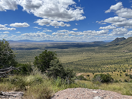 |
If you look closely at the eastern view, you can see a dark line where various administrations have erected border fencing. Those fences are notably absent when you look west.
Here is what that fence looks like from the ground, looking again west.
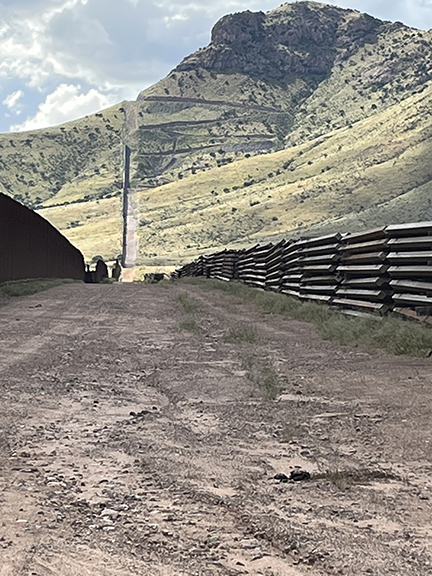 |
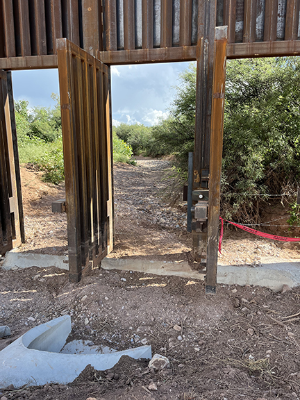
As you can see, the fence runs up the mountain and abruptly stops. The terminus of the wall is where construction was halted by President Biden days after he took office, and the panels to the right were supposed to be installed up and over the mountain. Now, they are simply a hazard, stacked up as far as the eyes can see.
There are two notable landmarks as you look west along the fence line. The first is the zigzag cut into the hill. That was a switchback road, which was supposed to provide all-weather access to Border Patrol agents and local authorities.
I say it “was a switchback road” and “was supposed to provide all-weather access” in the past perfect tense for a reason. When Biden halted construction of “the wall”, all construction shut down, including the road. Because the road surface was not completed, seasonal rains have largely washed it away, and DHS has shut down access to it as a hazard.
The other landmark is also visible in this picture, but you must know where to look.
As the mountain slopes down, there is a lone tree on the point, to the top left. Directly beneath that tree is a small stone shelter, which houses a spotter for the Sinaloa cartel. You will have to trust me on that one, because you need binoculars to find the spotter, but I was told that he (or she) is there, 24-7, 365 days a year.
Local police and Border Patrol agents must hike up the mountain now that the road has been washed out, and can see the well-provisioned spotter, but there is nothing they can do — the tree is on the Mexican side, and U.S. authorities have no jurisdiction there.
From that point, the cartel confederate can keep watch on U.S. authorities for tens of miles in either direction and convey that information to drug and human smugglers.
For the environmentally minded, the then-current spotter in that location is also blamed for starting the “Monument Fire” in June 2011, which burned more than 32,000 acres and destroyed 84 houses and other structures. Even though it happened more than a decade ago, the scars of that fire can still be seen all around, in the form of charred trees and scorched bark.
The Hazards of Poor Policy. The rusting fence panels are not the only indicia of the Biden administration’s poorly thought-out and knee-jerk decision to halt border barrier construction.
Mounds of ground-up rock — intended as paving material — dot the dirt road along the border, as do jersey walls that had been shipped to the site and left there when Biden called his halt.
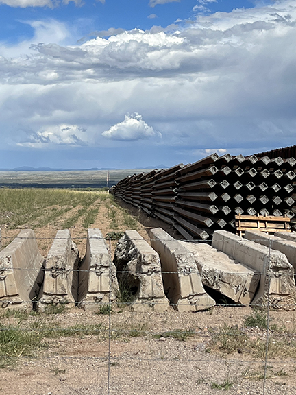 |
Those piles of wasted building materials create a hazard, as they can be used by smugglers to hide from, evade, and attack responding Border Patrol agents and local officers. But because the border wall system is an “all-in-one package”, those materials cannot be removed any more than they can be used.
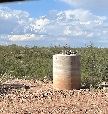
Speaking of that “all-in-one package”, the border in Coronado National Monument is dotted with light poles and light-pole foundations. They are all useless, however, because the lights themselves have never been hooked up, and the foundations sit uncompleted, even though the infrastructure to complete and power them is largely in place.
 |
And yet it gets worse. Because the fence road has never been completed, it is prone to washouts in an area subject to flash flooding from the south. Drainage would have allowed that water to flow freely, but because it has never been finished, debris pushes up on the south side of the fence, threatening to undermine and topple the portions of the fence that have been completed.
There are flood gates in the fence, but in places they are more impediment than improvement.
 |
The “monsoon season” in the desert runs from the late spring through the summer, and I was told that these flood gates have been open since May.
Access through that open gate could be controlled if there were enough Border Patrol agents and cameras to keep watch on this section of the fence, but again, those cameras were meant to be part of the (incomplete) wall system, and there are far too few agents stationed there.
As of the end of FY 2020, there were 3,615 agents in the Border Patrol’s Tucson sector, which includes Cochise County and the monument, responsible for 262 miles of largely rugged and wide-open border. Those agents are so thinly stretched processing, caring for, transporting, and (often) releasing illegal entrants that the local highway checkpoint is closed, and has not been manned for months.
SABRE. During the days that I spent in the monument and Cochise County, I never saw a uniformed Border Patrol agent, though I did spot four plainclothes agents who were attached to an initiative of the Cochise County Sheriff’s Department called “Southeastern Arizona Border Region Enforcement (SABRE)”.
SABRE is the brainchild of county Sheriff Mark Dannels, and as part of that initiative, local deputies have jerry-rigged and operate hundreds of “Buckeye” game cameras at strategic spots along the border. Officers and agents attached to the program can then be dispatched to apprehend those who illicitly traverse the border.
While SABRE has been effective in deterring drug smuggling across the border in Cochise County, human smuggling is a different issue. Most of the migrants who cross there are not “give-ups”, that is migrants seeking to turn themselves into Border Patrol, but rather would-be “got-aways”, seeking to evade detection and apprehension to travel into the interior.
They are mostly males of military-age, and almost exclusively dressed head-to-toe in camouflage. In an interesting anecdote, I was told that the smugglers send so many migrants across that they are facing supply shortages south of the border.
While their intentions are usually unknown, upwards of two-thirds of those illegal crossers successfully make their way into the United States. And local officers can only hold migrants themselves for a “reasonable time”, so if Border Patrol can’t respond, they must reluctantly release the ones they catch who are not trafficking drugs and who have no criminal history in the United States.
That’s unacceptable by any measure, but still the local residents to whom I spoke are grateful to the sheriff’s office for undertaking what is, fundamentally and ultimately, a federal responsibility. While the White House may not care about their lives and property, Sheriff Dannels and his team of MacGyvers do.
Incalculable Waste. How much of the border infrastructure in Coronado National Monument has been wasted due to the president’s intransigence? Good question, and not surprisingly the White House isn’t telling, though I was quoted figures of up to $125 million in washed-out roads and rotting material.
As infuriating as the fiscal costs are, the lost opportunities are worse. Biden, who trumpeted himself as a proponent of border walls during his earlier White House races, derided them during his 2020 presidential run, contending on his campaign’s immigration website: “Building a wall will do little to deter criminals and cartels seeking to exploit our borders.”
Biden’s assertion that border fencing “will do little to deter criminals and cartels” is demonstrably false in Cochise County, Ariz. Instead of securing the border there, his administration’s policies have created impediments that facilitate criminality and endanger local cops and Border Patrol alike while costing Americans millions of dollars. We will all pay the price for years to come.


